


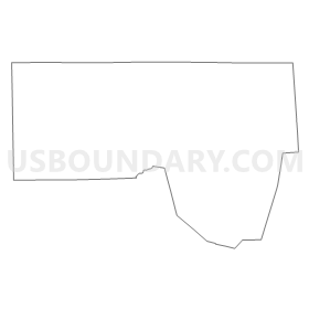
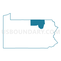
Bradford, Tioga & Sullivan Counties PUMA, Pennsylvania
About
Outline
Summary
| Unique Area Identifier | 193841 |
| Name | Bradford, Tioga & Sullivan Counties PUMA |
| State | Pennsylvania |
| Area (square miles) | 2,750.48 |
| Land Area (square miles) | 2,731.13 |
| Water Area (square miles) | 19.35 |
| % of Land Area | 99.30 |
| % of Water Area | 0.70 |
| Latitude of the Internal Point | 41.72076750 |
| Longtitude of the Internal Point | -76.82969180 |
Maps

Graphs
Select a template below for downloading or customizing gragh for Bradford, Tioga & Sullivan Counties PUMA, Pennsylvania


Neighbors
Neighoring Public Use Microdata Area (by Name) Neighboring Public Use Microdata Area on the Map
- Broome (Outer West) & Tioga Counties PUMA, NY
- Chemung (South) & Steuben (East) Counties--Greater Elmira & Greater Corning Cities PUMA, NY
- Clearfield, McKean, Elk, Potter & Cameron Counties PUMA, PA
- Columbia & Luzerne (West) Counties--Bloomsburg Town & Berwick Borough PUMA, PA
- Lackawanna (Outside Greater Scranton City) & Wyoming Counties PUMA, PA
- Lycoming & Clinton Counties PUMA, PA
- Pike, Wayne & Susquehanna Counties PUMA, PA
- Steuben (North & West), Schuyler & Chemung (North) Counties PUMA, NY
Top 10 Neighboring County (by Population) Neighboring County on the Map
- Luzerne County, PA (320,918)
- Lycoming County, PA (116,111)
- Steuben County, NY (98,990)
- Chemung County, NY (88,830)
- Columbia County, PA (67,295)
- Bradford County, PA (62,622)
- Tioga County, NY (51,125)
- Susquehanna County, PA (43,356)
- Tioga County, PA (41,981)
- Wyoming County, PA (28,276)
Top 10 Neighboring County Subdivision (by Population) Neighboring County Subdivision on the Map
- Owego town, Tioga County, NY (19,883)
- Southport town, Chemung County, NY (10,940)
- Barton town, Tioga County, NY (8,858)
- Sayre borough, Bradford County, PA (5,587)
- Athens township, Bradford County, PA (5,251)
- Mansfield borough, Tioga County, PA (3,625)
- Athens borough, Bradford County, PA (3,367)
- Charleston township, Tioga County, PA (3,360)
- Wellsboro borough, Tioga County, PA (3,263)
- Towanda borough, Bradford County, PA (2,919)
Top 10 Neighboring Place (by Population) Neighboring Place on the Map
- Sayre borough, PA (5,587)
- Waverly village, NY (4,444)
- Mansfield borough, PA (3,625)
- Athens borough, PA (3,367)
- Wellsboro borough, PA (3,263)
- Towanda borough, PA (2,919)
- Canton borough, PA (1,976)
- Elkland borough, PA (1,821)
- Blossburg borough, PA (1,538)
- Troy borough, PA (1,354)
Top 10 Neighboring Unified School District (by Population) Neighboring Unified School District on the Map
- Elmira City School District, NY (48,734)
- Keystone Central School District, PA (37,799)
- Corning City School District, NY (34,133)
- Tunkhannock Area School District, PA (19,039)
- Jersey Shore Area School District, PA (17,858)
- Southern Tioga School District, PA (15,719)
- Athens Area School District, PA (14,779)
- Owego-Apalachin Central School District, NY (14,608)
- Northern Tioga School District, PA (14,523)
- Montoursville Area School District, PA (13,205)
Top 10 Neighboring State Legislative District Lower Chamber (by Population) Neighboring State Legislative District Lower Chamber on the Map
- Assembly District 136, NY (124,338)
- Assembly District 123, NY (124,261)
- Assembly District 137, NY (123,427)
- State House District 109, PA (62,749)
- State House District 117, PA (60,701)
- State House District 111, PA (59,947)
- State House District 110, PA (59,579)
- State House District 68, PA (59,039)
- State House District 84, PA (57,244)
- State House District 67, PA (56,066)
Top 10 Neighboring State Legislative District Upper Chamber (by Population) Neighboring State Legislative District Upper Chamber on the Map
- State Senate District 53, NY (295,046)
- State Senate District 52, NY (290,862)
- State Senate District 20, PA (273,416)
- State Senate District 27, PA (256,971)
- State Senate District 23, PA (248,605)
- State Senate District 25, PA (233,497)
Top 10 Neighboring 111th Congressional District (by Population) Neighboring 111th Congressional District on the Map
- Congressional District 11, PA (687,860)
- Congressional District 22, NY (679,297)
- Congressional District 10, PA (669,257)
- Congressional District 29, NY (663,727)
- Congressional District 5, PA (651,762)
Top 10 Neighboring Census Tract (by Population) Neighboring Census Tract on the Map
- Census Tract 206, Tioga County, NY (7,396)
- Census Tract 9505, Bradford County, PA (6,278)
- Census Tract 9506, Tioga County, PA (6,021)
- Census Tract 105, Lycoming County, PA (5,798)
- Census Tract 9509, Bradford County, PA (5,702)
- Census Tract 9503, Bradford County, PA (5,587)
- Census Tract 112, Chemung County, NY (5,394)
- Census Tract 9512, Bradford County, PA (5,267)
- Census Tract 9507, Tioga County, PA (5,251)
- Census Tract 501, Columbia County, PA (5,233)
Top 10 Neighboring 5-Digit ZIP Code Tabulation Area (by Population) Neighboring 5-Digit ZIP Code Tabulation Area on the Map
- 17701, PA (44,661)
- 14901, NY (16,736)
- 13827, NY (11,759)
- 18840, PA (10,731)
- 16901, PA (10,243)
- 18848, PA (9,193)
- 14892, NY (8,189)
- 13732, NY (8,153)
- 16933, PA (7,488)
- 17737, PA (6,220)